Features
Bringing Home the Goods
TCI’s most avid adventurer returns to East Caicos.
By John Galleymore ~ Photos By Agile LeVin
On the starting line of my first London Marathon, I was advised by a veteran runner to “keep my head up and look around . . .” Bizarre advice I thought, and then I proceeded to run the 26 miles in a blur, so intent on finishing, with hardly a recollection of doing so even to this day. With every marathon since, I now relax, keep my head up and enjoy the sights, sounds, and experience of the day. And it’s a far more enjoyable experience! (Maybe that’s a metaphor for life in general!)

The author investigates an old bottle found at the Goods Hill Settlement on East Caicos.
We all decided to set a goal for the 3 day/2 night trip. This included diving some natural ponds and sinkholes and trying to locate long-lost plantation ruins. During our planning meetings, we pored over charts and Google images. Daniel and Agile also supplied some great old maps, and having lived in the TCI for 22 years they have invaluable island exploring and research experience.
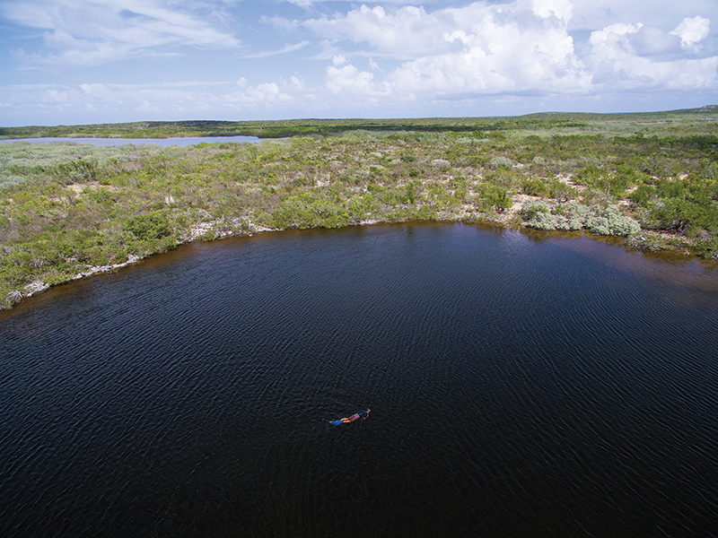
Jon Ward snorkels in one of East Caicos’ eerie sinkholes.
We decided to set off from South Caicos and head to the southern point of East Caicos, and after studying various maps and old books we decided to try to locate the mysterious Goods Hill Plantation, an old 1800s settlement possibly used for cattle. We had seen it mentioned briefly in various books but its location was not marked on any map and it was steeped in rumor and hearsay.
Prior to our start date we contacted a South Caicos local Tim Hamilton, who agreed to take us by boat to East. Tim comes highly recommended by Mark Parrish (Big Blue Unlimited) and Val Kalliecharan (Turks & Caicos Reservations) so there was never any doubt we had chosen the right guide! Arrival times were agreed upon, flights booked and provisions packed, and a few weeks later our flight touched down in charming South Caicos.
Despite an unscheduled delay, Tim is there on time to meet us with coffee in hand and a beaming smile. After loading up Tim’s truck with our extensive kit (at which I’m sure he raised an eyebrow or two) we set off for the dock. Tim drives slowly, pointing out sights on the way, proud of his native island. After a brief supermarket stop for water and snacks we are joined by Tim’s son Tamall and board the boat.
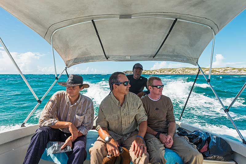
Tim Hamilton (at back) pilots the intrepid group to East Caicos.
We journey past the remote and beautiful Plandon, Middle Creek, and McCartney Cays with their deserted beaches, lush vegetation, and rocky outcrops. We are luckily enough to spot four ospreys circling above us, a truly wonderful sight.
While we can’t get to the exact landing point we would like, due to ironshore, we decide on a small bay that Tim knows well. It’s close to McCartney Cay and I remember that it’s calm and sheltered. Tim drifts close enough so that we can wade knee-deep ashore and ferry our supplies to the beach.
Although East Caicos is uninhabited we are met on the beach by a welcome party — only it consists of millions and it’s not very welcome! The dreaded mosquitoes seem none too pleased by our arrival and attack us en masse the moment our feet touch the sand. So with head nets and gloves on, we speedily cache our kit in the nearby bush. Our plan is to explore and find a suitable campsite along the way with the four to five hours of daylight remaining.
Jon, Daniel, and Agile head along the coast while I climb the nearby hill, which being named Goods Hill on some old maps is our clearest indication that we are in the right location of our goal. I give Daniel a marine flare for emergencies and Jon a walkie-talkie so we can check in every hour.
The climb to the top of Goods Hill is hard. Thick brush carpets every square foot and most is chest high, with thick springy branches entangling and holding me back with every step. Mosquitoes buzz constantly around and I pull my neck scarf up so only my eyes are visible. I know from experience that a machete is near useless here as the saplings are so springy they are all but impossible to cut through. Threading my way with both care and brute force is often the only way to cover even the shortest distance.
After some time, I start to climb more steeply, the bush thins out to bare limestone, and the breeze picks up, seeing off the last of my persistent adversaries. The view from the peak is worth the climb — 360º of unspoiled beauty. I see South Caicos in the distance, Flamingo Hill behind me, and all around natural untouched vegetation and wetlands, oozing with a huge diversity of plant and wildlife.
East Caicos must surely be the last true wonder of the Turks & Caicos Islands and it is imperative that this jewel is not lost or destroyed. In a world that has embraced ecotourism and the revenue generated by low impact developments, East Caicos is a prime example of what could be an authentic National Park. It would be wonderful to see the TCI take the initiative and set this island aside for future generations (and visitors) to enjoy in its natural, undeveloped state.
In the cooling breeze of the summit, I take a bug-free rest and see the three guys picking their way along the coast a few miles away. I decide to head down and follow, although the descent is almost as difficult. On the coast there are few bugs as the wind and sea spray is constant and refreshing. Soon, I see the guys in the distance and in a radio check Jon says “Some walling found!” I fight my way through more relentless bush to meet up with them.
In fact, it’s more than walling we have found, we stand amongst stone foundations no more than a few feet high which are losing a battle with the surrounding bush that has been ongoing for centuries. The stones are obviously an old house, and in good order. Miraculously we even find a fireplace — not uncommon with TCI ruins — but this is the first with red clay, purpose-made bricks! It’s beyond belief that we have actually stumbled upon the Goods Hill Settlement on our first day!
The site seems to be made up of two dwellings a short distance apart. One is the main house with kitchen/fireplace, the other a plain square with single doorway. Both have walls in good condition, remarkable given their age. We scour the site finding pottery, more bottles, and even copper pieces from an old oil lamp. We are careful to leave items as undisturbed as possible, conscious of the fact that this area is of historical value and we must be amongst only of a handful of visitors here in the last 200+ years.
The numbers of intact bottles are in the dozens. We see the common wine bottles, some of handmade black glass, and the distinctive shapes of brown “gin” bottles too. A few smaller, possibly medicinal bottles are marked with such names as “Indian Arrow Root,” “Agua de Florida,” and more commonly, “Listerine!” Again, as with any ruin I visit, I marvel at the determination and sheer audacity of those past souls choosing to settle and survive in these remote areas.
The group decided to head back while I explored a small pond nearby, which involved more thick brush navigating. After tasting the brackish water, I conclude this must be the nearest water source for the settlement.
Back at the bay, the guys had located a good campsite and started erecting tents and making a small fire to keep the bugs off. Luckily it was quite breezy, so the mosquitoes were not too bad here. We discussed our day over an evening meal around the fire. We could only imagine what other hidden wonders lay out there in the “wilderness!” Tomorrow, Jon, Agile, and Daniel plan to walk to the ponds. Weight restrictions meant SCUBA is out, but they pack snorkel gear and also a drone to catch some aerial footage of the area. With the fire crackling away, the bugs all but gone, and stars out by the billion, we retire to out tents and sleep until dawn.
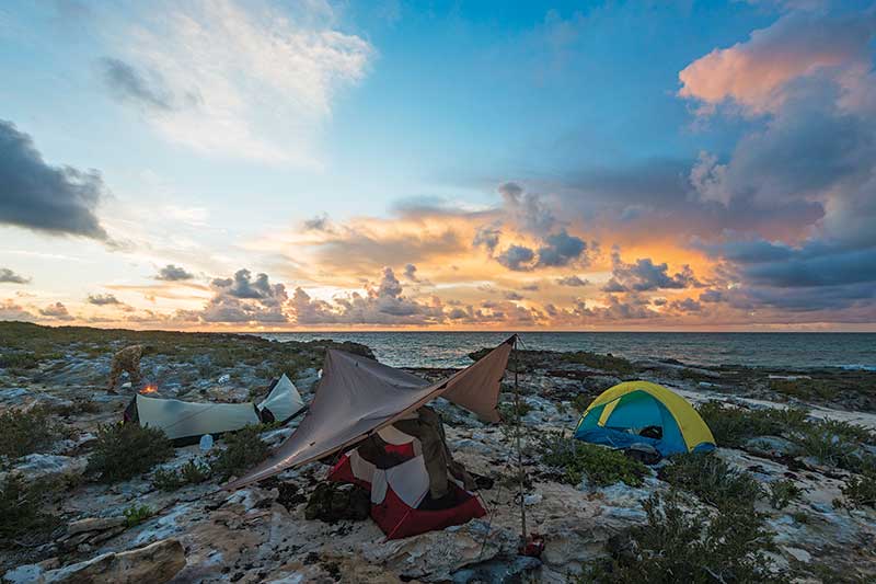
The trekkers enjoy a lovely sunrise over base camp.
The guys set off for the ponds packing all the gear and I set off around the base of Goods Hill. My plan today is to look for artifacts and even caves, which given the limestone in the area, is a good possibility. I continue to climb and descend for most of the day, again struggling through bush and scrabbling over rocks. Despite the season, the heat is oppressive and bugs persistent.
During one period of rest atop the summit of a limestone ridge, I sit quietly enjoying the birdsong and tranquility when I am rewarded by a donkey and her foal walking past a mere dozen feet away. I walk for another few hours, then return to camp. I decide to swim — clothes, boots, and all — in the cool waters of the bay. I soak for a good hour or so and it feels like the best spa on earth!
As I float and relax, I wonder how the guys are getting on, and once back at camp, Jon later recounts . . .
“Time was not on our side with the long hike up the rocky coast followed by trying to find a route through the mosquito-filled bush and wetland. Agile had the ponds pre-plotted on his GPS and it seemed every mile we’d ask ‘How much further?’ to which he’d reply ‘only another half mile.’
“We eventually arrived at one of the ponds, and I ensconced myself in the shade under a bush nursing my blisters and bruised toenail. Agile and Daniel set up a small camp fire to try to smoke out the hungry mosquitoes. Once the smoke had deterred most of the bugs, I was ready to snorkel. I carried a SCUBA depth line to try to ascertain the bottom depth. Agile and Daniel set up the drone to capture some awesome images.
“The water temperature was very refreshing as I swam slowly to the edge of the drop off. Some small fish darted left and right, along with some larger fish roughly six inches long. A promising sight for such a land-locked pond, or could this or other ponds be linked to the ocean as many believe?
“Swimming over the sinkhole was very eerie. Visibility was poor and with a mixing layer of fresh and salt water inches below the surface, the brackish water would often change from a glint of red to green. I could not tell if I was floating above a 200 foot hole or 10 foot hole, but with several line drops I was only getting about 20 feet of depth, which was very frustrating. Looking back at the drone images later on, it seems I missed a darker (and possibly much deeper) patch in the pond.
“I did some free-diving by the wall edge of the sinkhole and noticed a lot of fish activity. I also felt a huge temperature change from refreshing 83ºF. water to close to 90ºF. water a few feet below the surface. I also spotted some nice limestone rock features.
“That was enough, as time meant we had to make a move. I walked back to the smoke with no mosquitoes in sight, allowing me to peacefully dry off, get changed, and pack my gear. We all headed back following donkey trails and fighting through the thick bushes to the coastline.”
I was still swimming when Jon returned to camp, surprisingly on his own. It seems Agile and Daniel had decided to press on in the opposite direction to Drum Point. I admired their fortitude as I recalled the beach to Drum Point is horrendous to walk, due to its steep angle and deep soft sand. Jon swam for a while to cool off while I set the fire for the evening. It was close to sunset when I spotted Daniel and Agile heading back down the coast.
Dinner around the fire was a relatively bug free affair, so much so that we were able to lay out on the sand, discuss the day, and admire the stars and spot passing satellites. Sleep soon came on the eve of our last day, and we had a few hours to spare in the morning before Tim returned to pick us up. After another great sunrise and quick breakfast, I set off in search of more limestone caves. As I walk along the high ridge, I spot Agile in the distance setting up the drone on the plantation site some miles away. He should get some great shots and record important detail, especially useful for the National Trust, which we all support avidly.
As I descend through the bush, I hear the drone overhead and see it whizzing through the clear sky — technology sure is making exploration easier! I also bump into Daniel who has come across some ancient wooden planks, held together with now-rusty bolts. They sit in the middle of desolate bush, with nothing man-made for miles around. What purpose they once served will forever be a mystery.
I soon find myself back on the beach and head around to the quiet inlet that separates East Caicos from McCartney Cay. After a brief walk and a short swim back, the guys are breaking camp for our departure. The fire is extinguished and all garbage collected. It’s like we were never here and that’s how it should be. Right on schedule, Tim arrives with Tamall and it’s smiles and greetings all around.
A hop into the boat and we are off, again zipping around coral heads while we discuss the joys of the last few days, as well as having a few moments each in quiet reflection. It’s been a pleasure to have shared this trip with some great guys and fellow-minded adventurers.
South Caicos arrives all too quickly and once docked, Tim celebrates our excursion by suddenly appearing with a six-pack of beer — good man indeed! Tim bids us farewell at the airport. We have some hours before our flight but it’s good to just relax, chill, discuss our fantastic trip . . . and plan the next one!
•To contact the author for information on island exploration and guided tours, use beyondtci@gmail.com or visit www.facebook.com/BeyondTCI.
•Agile and Daniel LeVin are photographers and editors for Visit Turks and Caicos Islands (www.visittci.com)
•To learn more about the TCI National Trust (their work and historic sites), go to www.tcnationaltrust.org.
•For tour arrangements on South Caicos and beyond, call Tim Hamilton Tours at 649 345 6616.
What's Inside The Latest Edition?

On the Cover
South Caicos was once a major exporter of salt harvested from its extensive salinas. Award-winning Master and Craftsman Photographer James Roy of Paradise Photography (myparadisephoto.com) created this vertical composition by assembling a series of six images captured by a high-definition drone which was a half a mile away from his position.
Our Sponsors


Leave a Reply