Astrolabe
Crawling with Intrigue
What are the mysterious underwater features in Corey Pond?
By Glen Freimuth, Shaun Sullivan, Charlene Kozy, and B Naqqi Manco
Archaeologists are always looking down at the ground for this is the location of their stock and trade, signs of past remains. One of us, Shaun Sullivan, was looking down upon Middle Caicos with the aid of Google Earth (Digital Globe) satellite images and observed something unusual in Corey Pond, a salt water feature located one kilometer northwest of Bambarra. It appeared as lines of subsurface rock walls arranged in rectangular units. This piqued our interest because we had conducted archaeological excavations at a Lucayan site, MC-12, located 800 meters northwest of the Pond. Could these strange features be associated with the thirteenth century occupation of MC-12? We needed to conduct an onsite inspection.
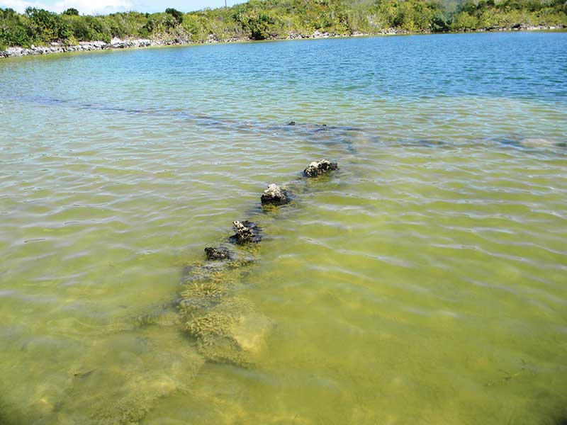
Submerged rock walls of Corey Pond as seen from ground level.
We conducted limited test excavations within and along the walls, screening the sediments in the hope of recovering diagnostic artifacts, but alas, found nothing but some very small fish and bivalves. We surveyed the surrounding shore banks for evidence of prehistoric activity but recovered nothing.
We tried to think how the Lucayans may have utilized such features — ocean catch holding pens or the foundations for structures? With the lack of any prehistoric artifacts or associations we turned to the historic era for possible answers. We made inquiries to several older residents in Bambarra about the pond features but no one we spoke to could recall the features or their function. Was this a dead end?
Interestingly, we recently conducted research on Cotton Cay where the topic of sisal production in the Islands emerged. According to H.E. Sadler’s Turks Islands Landfall, sisal was introduced into the Caicos Islands in the mid-1800s by Henshall Stubbs. By the 1890s world demand for sisal products grew and large sisal plantations were established on East Caicos (3,000 acres) and West Caicos (1,000 acres). By the early 1900s these commercial enterprises had ceased production. In the mid-1940s demand for sisal products again increased and 600 acres in the Caicos were planted in sisal with production until the mid-1950s, but these commercial operations seemed to have ceased by the late 1950s. They relied upon mechanization to crush the sisal leaves and extract the fibers which were then dried in the sun but not allowed to get wet. However, small scale or local sisal production was not mechanized and required the cut sisal leaves to be soaked in fresh or salt water to soften the outer shell and extract the fibers.
We turned to two colleagues for assistance, Turks & Caicos historian Dr. Charlene Kozy and Turks & Caicos biologist/botanist B Naqqi Manco. Dr. Kozy’s research indicated the area around Corey Pond had been a 4,000 acre plantation owned and operated by Thomas Brown in the late 1700s. Indeed, the numerous stone walls, some very large like boundary lines, around and into Corey Pond bear witness to the plantation occupation. Brown planted numerous crops but not sisal, nor is there any record that his 600 slaves planted sisal. So it seemed the pond features are not associated with the Brown plantation activities.
Naqqi made some inquiries and in conversation with Brodie Forbes learned that the “rock crawls” as they are locally known (probably referring to corrals), were used to soak sisal produced in small scale local production by Islanders. They retained the soaking sisal within the crawls, preventing them from floating over the entire pond. This production was apparently sold to a local sisal mill in Bottle Creek, North Caicos which ceased operation sometime in the 1960s. In addition, the construction of the crawls is consistent with the many kilometers of plantation walls throughout the Turks & Caicos Islands. But the question remains, “Why use Corey Pond?”
There are several other ponds nearby — Flamingo Pond, Washing Pond, and a pond along the Bambarra Road. Flamingo Pond and the Bambarra Road pond have fish and Washing Pond is a fresh water source, so named because the women from Bambarra would use it to wash clothes during dry periods. None of these ponds have any known features like Corey Pond. The answer may be ownership, convenience, or location — we simply do not know at this time.
So it would appear we have an explanation for the mysterious Corey Pond features: Probably constructed ca. 1950 for local sisal production and used by Islanders until the 1960s to soak sisal leaves and extract the fibers which were then sold to a mill in Bottle Creek.
Mysteries still beckon the archaeologist. Indeed, it would be interesting to have divers enter the hole in the center of the pond and explore its interior.
Dr. Glen Freimuth is a retired archaeologist, Dr. Shaun Sullivan is a retired archaeologist, Dr. Charlene Kozy is a retired historian, and B. Naqqi Manco is the Caicos Pine Recovery Project Manager working for the Department of Environment and Maritime Affairs.
2 Comments
were the inhabitants from Greenwich turned over to henshall stubbs, or a mr. wymess. still trying to find them.
Leave a Reply
What's Inside The Latest Edition?

On the Cover
Sun-drenched and unapologetically bold, photographer Renau Destine www.renaudestine.com captures modern island luxury with runway confidence in this shot of 2026 TCI Top Model Contest winner Trevor Watkins. Here, the Grand Turk native wears a crisp blush shirt and rich berry shorts to strike the perfect balance between relaxed elegance and statement style.
Our Sponsors


i am still looking for more history about Greenwich plantation. what happen to the inhabitants.