Astrolabe
The Island Within the Island
Solving the mystery of Grand Turk’s island cemetery.
Story & Photos By Dr. Donald H. Keith, President, Turks & Caicos National Museum Foundation
Beneath those rugged elms, that yew-tree’s shade,
Where heaves the turf in many a mould’ring heap,
Each in his narrow cell for ever laid,
The rude forefathers of the hamlet sleep.
—Thomas Gray, 1751
Elegy Written in a Country Churchyard
Grand Turk has an unusual geographical feature. In the middle of the island there is a large, shallow lake — the “Town Salina.” In the middle of the lake is “The Island,” actually an island within an island. But that is not what intrigues me. The island rears well above the salina and is connected to the surrounding dry land only by a narrow, obviously man-made causeway. Crowned by a thicket of acacia bush the island looks desolate and abandoned — and it is. Horses and donkeys occasionally find their way out to it, but no one goes there.
The island first came to my attention in 1981, during my second trip to Grand Turk. It was so peculiar that I was compelled to have a look. At the end of the causeway was a small abandoned shack, falling into ruin. I walked around the island’s perimeter on a narrow sandy beach, littered like an elephants’ graveyard with junked and abandoned hulking, rusting motor vehicles and heavy machinery.
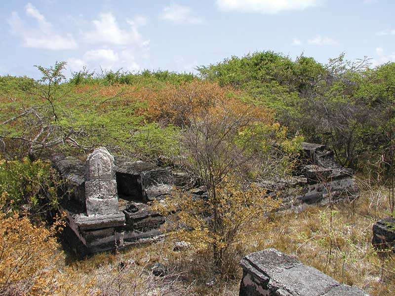
A group of coffin-shaped markers found on The Island on Grand Turk.
I spent the rest of the afternoon there, examining and photographing the site, looking for clues as to how old the graveyard was, who was interred there, and what their religious affiliation might have been. In spite of my efforts I left without being able to answer any of these questions. No inscriptions were preserved, and there were no mortuary symbols that I could recognize. The most distinctive feature was a group of coffin-shaped elevated tombs unlike anything I had seen elsewhere.
Later, excited and puzzled by my discovery, I began asking “old heads” and expats if anyone knew anything about the graveyard and if so, what. Although everyone I spoke to had heard about the graveyard, there was no agreement on when it was created, who was there, or what significance it had. I was told with absolute certainty by various informants that the cemetery was specially for “war heroes” (!), victims of a seventeenth century plague, slaves, criminals, Bermudans, and people who for one reason or another were not buried in one of the church yards. It was clear that these explanations were based on conjecture with no real evidence to back them up, and most were highly unlikely to say the least. So who were they? The surprising thing to me was that no one seemed to be bothered by the fact that there was, literally in the middle of Grand Turk, a major, very old, and historically significant cemetery comprising scores of burials about which the community knew less than nothing.
A few years later I assembled a four-person Ships of Discovery project to map, photograph, and record the accessible parts of the cemetery. We discovered that although there is no visible wall or boundary for the cemetery’s overall perimeter, the majority of the graves and tombs seem to be concentrated at the island’s crest and to cover an area of about 2,000 m2 with an East–West axis length of approximately 60 m and a North–South axis of about 35 m. At some time in the recent past the base of the island was bulldozed, apparently at random and without consideration for the sacrilege such an act represents, and an unknown number of graves were destroyed. Human bones still littered the surface of the earth. Their slopes steepened by bulldozing, the sides of the island’s crest had begun to erode and slump, causing further damage.
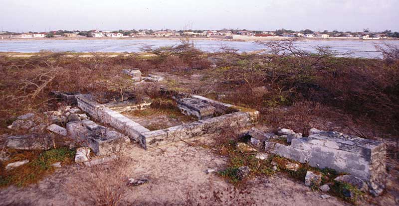
The old cemetery covers the top of The Island, with graves and tombs scattered around the sides.
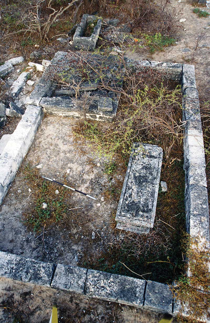
One of the larger enclosures of The Island’s cemetery.
The first breakthrough occurred sixteen years later when Museum Founder Grethe Seim discovered an official Ordinance passed in 1861 mentioning “The Island” on Grand Turk and the “North Bluff” on Salt Cay as the burial grounds for “the remains of many of the earlier settlers on these Islands.” The Ordinance provided for the creation of a Commission “empowered to have all such burial grounds cleared and kept clean at the public expense of enclosing, cleaning and keeping clean, [the cost] to be defrayed out of the Public Treasury.” If nothing else, this document told us that even as early as 1861 the cemetery on “The Island” had fallen into disuse and abandonment, which certainly implied that many decades had passed since the last interment there.
With a growing suspicion that the graves were related to early Bermudan settlers of the Turks Islands and dated to the eighteenth century — or even earlier — and nothing more to go on than the mortuary architecture itself, we began to look for similar grave and tomb designs in Bermuda. In 2009 I happened to attend a presentation by Dr. Bruce Elliott, Professor of History at Carleton University in Ottawa, in which he showed images of what he called “body stones” in a cemetery in Bermuda. They were exactly like the “coffin-shaped” markers I had seen on “The Island” and at the North Bluff! A lively correspondence and exchange of photos ensued. Intrigued by the photos and descriptions I sent, Dr. Elliott immediately recognized mortuary characteristics he was familiar with in Bermuda.
“There is a white headstone clearly visible at the left, mounted at the end of one of the body stones. It bears a striking resemblance to a common type of Bermuda marker made of the local aeolian limestone. I attach a photo of a similar stone in the slaves and free blacks section of St Peter’s churchyard in St George’s. The inscription panel (which in Bermuda often had simply initials) typically is surrounded by a single or double recessed edge and has incised lines dividing it off from the lower part of the stone, as in your example. The one in your photo looks to be made of the soft Bermuda stone. These are impossible to date as the surviving examples are mostly illegible, though I have seen some from the 1760s, and until further information comes in I would be hesitant to place them more exactly than the long 18C, i.e. including possibly earlier or later.
“The other photo shows a profusion of body stones at Christ Church in Warwick. These are more characteristic away from St George’s, but like the more elaborate tombs they are impossible to date as any inscriptions have long since worn away. You will observe that these are coffin-shaped and have foot and headstones flanking them. I would think the key feature from your perspective would be whether what you have are made of Bermuda stone. The headstone that I commented on before is I would say definitely a Bermuda product as it so closely resembles the common run of headstones in Bermuda that were made of the local material in the 18C. I have seen dated ones from the 1740s–60s, but the vast majority are worn to illegibility. The headstone in T&C would have been made in Bermuda and brought down; the flat tombs would be much more likely to have been made in T&C, especially if there is local architectural stone there.”
Standing atop the island within the island in the fading light of sunset, surrounded by the ancient cemetery, I use what we have learned over the last thirty years to answer my own questions. Who lies here beneath my feet? Almost certainly they were second- or third-generation eighteenth century Bermudan settlers, by which time salt rakers were living on Grand Turk year-round.The workmanship and elegance of the tombs and headstones imply that they were prosperous and pious. What faith did they observe? While some of the tombs and markers bear a strong resemblance to examples at St. Peter’s Anglican Church in Bermuda, the coffin-shaped “body stones” are similar to those found at Christ Church in Warwick, which is part of the Presbyterian Church of Scotland.
Why create a cemetery on an island within an island instead of land associated with a church? This is a question for which there is no certain answer. In some ways, the island is a natural location for a cemetery. A simple fence across the causeway would have prevented livestock from entering to graze and damage the monuments (still a problem in all the cemeteries on Grand Turk!). The dead are laid to rest overlooking the Town Salina, the source of their community’s prosperity. Carefully tended and kept clear of overgrowth, the cemetery would have been a prominent and conspicuous memorial to, and reminder of, who the early settlers were.
Why did the cemetery lapse into anonymity? We found no evidence that it was within the grounds of an ordained church. Perhaps it was an extended family plot rather than a public graveyard. At some point it fell into disuse, probably when the last family members died out or moved away. No one was left who felt a personal attachment to the cemetery or sense of responsibility for its upkeep. It is not an uncommon fate and recalls another verse from Thomas Gray.
Yet ev’n these bones from insult to protect,
Some frail memorial still erected nigh,
With uncouth rhymes and shapeless sculpture deck’d,
Implores the passing tribute of a sigh.
What's Inside The Latest Edition?

On the Cover
Sun-drenched and unapologetically bold, photographer Renau Destine www.renaudestine.com captures modern island luxury with runway confidence in this shot of 2026 TCI Top Model Contest winner Trevor Watkins. Here, the Grand Turk native wears a crisp blush shirt and rich berry shorts to strike the perfect balance between relaxed elegance and statement style.
Our Sponsors


Leave a Reply