

Astrolabe
A Beacon of Safety
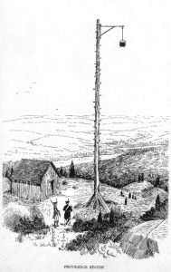
One of the goals of the survey was to relocate an 18th century French beacon, similar to the one pictured here.
Shining a light on Great Sand Cay.
Story & Photos By Spencer Bennett
In 2023, I joined The Shipwreck Survey on a maritime archaeology expedition to the Turks & Caicos Islands with Dr. Ruud Stelten, Alex Hinton, and Dr. Joost Morsink. Part of this expedition was archaeologically surveying Great Sand Cay and trying to relocate an 18th century French beacon.
When we got there, the island looked as if it’d been split into two separate islands with a small sandy walkway connecting them. So, we split into two teams and spread out to try and find the beacon. After we’d found it, our expedition team documented it at length before moving on to survey the rest of the island.
While documenting the beacon, we found numbers and arrows etched neatly into the rocks surrounding this temporary lighthouse. Bricks were strewn about haphazardly, which fits with it being demolished in a hurry. We also found little pieces of rusted metal in the rubble. I was initially confused about these. However, when I found a picture of what this French beacon might’ve once looked like, they suddenly made much more sense.
Now, while the numbers and arrows etched into the rock are still a mystery, the rest of this beacon’s mysteries have been solved. The little pieces of rusted metal were once attached to the bucket which would’ve held the lamp/light.
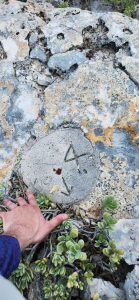
These artifacts were found during the survey of Great Sand Cay. Numbers and arrows were etched into the rock surrounding the temporary lighthouse.
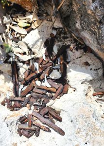
The small pieces of rusted metal had been attached to the bucket which held the lamp/light.
Using the picture above as a guide, we can see how this temporary lighthouse would’ve been constructed. The base was made with a combination of rocks and bricks. The pole would’ve been made of wood and brought ashore from a French Navy ship. The metal arm connecting the pole to the bucket would’ve been the final link in the chain with a rope securing the bucket in place. The bucket with the lamp could’ve been raised and lowered to either light or extinguish the lamp inside as needed.
The French military personnel manning this lighthouse in the “middle of nowhere” then carved Cardinal directions into the rocks surrounding the beacon. With their bearings etched into stone, they can safely vector passing ships around the hazardous waters of the island. Regardless of where the ship is or its bearing, they can rely on this fixed position on land to guide them to safety.
Maps from the 18th century tell us that this island was once known as Sand Key. During the French & Indian War (a.k.a. the Seven Years War; 1754–1763), Sand Key was in the custody of the French. According to history, the French had built a beacon on the southern point of the island as a navigational aid to French warships transiting the area. The island also had an anchorage off its western coast in case anyone needed it. However, soon after it was built, this beacon was hastily torn down. The French did this because with the end of the war, Sand Key then became a British possession. As such, the French didn’t want this beacon to be of any use to their enemy at the time — the British Royal Navy.
In the 18th century, these beacons were everywhere on the coastlines of the American continent and on Caribbean islands. They acted as lighthouses, were small and easy to assemble and demolish, and they were also effective at letting ships know where land was so they wouldn’t hit it.
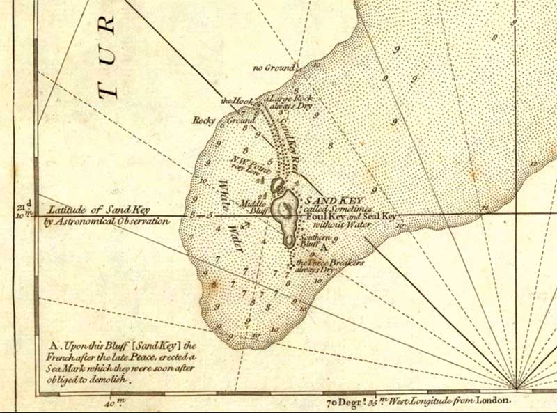
This 18th century map shows that Great Sand Cay was known as “Sand Key.” Note A mentions the “Sea Mark” erected by the French “which they were soon after obliged to demolish.”
Now, imagine for a minute that you’re a sailor in the French Navy during the 1760s. Your ship is sailing in the area of the Turks Islands and it’s the dead of night. As a sailor, one of your roles is as a lookout and you do this in shifts with other sailors on your crew. You’re responsible for keeping an eye out for obstacles that might wreck your ship. Your ship’s navigator is doing celestial navigation and there’s a blanket of stars in the sky above you.
On any normal night, lookout duty sounds like a good gig, right? Imagine you’re in that same lookout duty but it’s not a picturesque night. It’s foggy, you can’t see more than a few feet past your spot on the ship. The ship is in rough seas as you plunge up and down constantly. It’s gusty as the wind blows in your face, reminding you that there’s a storm looming somewhere nearby. In these conditions, how will you know where the neighboring islands are? The navigational charts in the Caribbean are still being written and re-written, as was the case with the HMS Endymion in 1790. Your shipmates are taking depth soundings every so often to make sure that your ship won’t run aground. However, depth soundings won’t be much help if you can’t see what’s surrounding your ship. What will save you from this fate? A lighthouse, perched on the shore, lit for all to see!
What's Inside The Latest Edition?

On the Cover
Local photographer Watsonne Morency (www.watsonnephotography.com) took to The Shore Club to capture this image of Miss Turks & Caicos International 2026 Adesha Gustave.
Our Sponsors


Leave a Reply